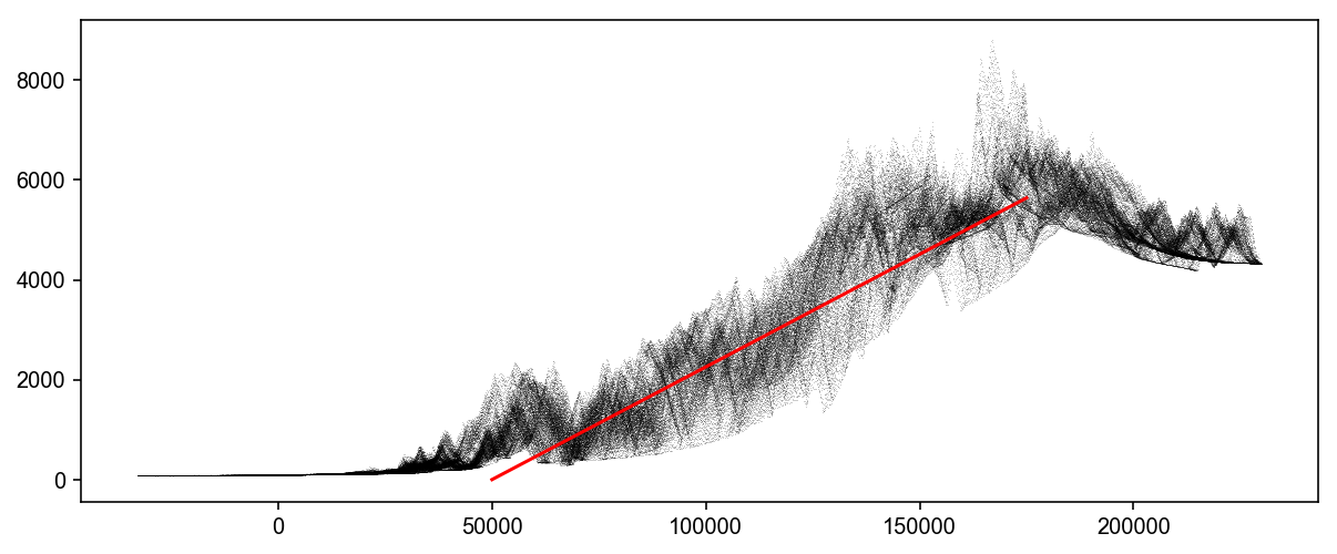
Exploring strength and stress relationships in critical wedges with raw topography data through Bayesian inversions
Cross-posted from the GEM Hazard Blog
One of the major annoyances of working in earthquake and tectonic sciences is the difficulty of browsing earthquake focal mechanism 'beachball' data, and plotting it in GIS. The typical way of displaying this data spatially is to use a script in Matlab (probably using …
I presented a talk yesterday at the USGS Earthquake Science Center in Menlo Park, California, on statistical paleoseismology in the Puget Lowland region of Washington State. I was a little nervous going into the belly of the beast to deliver this talk, with some of the world's experts on statistical …
cross-posted from the GEM Hazard Blog
cross-posted from the GEM Hazards blog
The Global Active Faults project of the GEM Foundation aims to produce a globally complete, reasonably homogeneous dataset of active faults on the Earth's surface for seismic hazard assessment. While most deforming regions of the world have some publicly available active fault datasets that …
I presented work done with Brian Sherrod (USGS Seattle) on paleoseismologic data in the Puget Sound region of Washington at AGU. In this work, I take ~30 paleoearthquakes and estimate their magnitudes with new methods that incorporate both rupture length and measured offsets, and then calculate recurrence interval probability distributions …
I've taken the new Matplotlib perceptually-uniform colormaps and converted them to QGIS color ramps. Check 'em out!
Earlier this spring, Dr. Tom Jordan of USC and the Southern California Earthquake Center caused a bit of a stir by claiming that the southern San Andreas fault was 'locked, loaded and ready to roll'. This was interpreted by many as meaning that an earthquake on the fault is 'overdue', although it's not clear what 'overdue' means in this scientific context. So what does this mean, and how should we adjust our expectations of when this tardy quake will arrive?
For the AGU Fall Meeting 2014, Eric Hetland and I presented a summary of our recent work on stress and fault property estimation in seismically active areas with high topography. Much of this work is featured in a forthcoming Journal of Geophysical Research paper (focusing on the 2008 Wenchuan event …